


Buffalo Voting District, Kershaw County, South Carolina
About
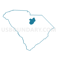
Outline

Summary
| Unique Area Identifier | 666168 |
| Name | Buffalo Voting District |
| County | Kershaw County |
| State | South Carolina |
| Area (square miles) | 56.97 |
| Land Area (square miles) | 56.75 |
| Water Area (square miles) | 0.22 |
| % of Land Area | 99.61 |
| % of Water Area | 0.39 |
| Latitude of the Internal Point | 34.54977800 |
| Longtitude of the Internal Point | -80.43786310 |
Maps


Graphs
Select a template below for downloading or customizing gragh for Buffalo Voting District, Kershaw County, South Carolina


Neighbors
Neighoring Voting District (by Name) Neighboring Voting District on the Map
- Angelus-Cararrh Voting District, Chesterfield County, SC
- Bethune Voting District, Kershaw County, SC
- Gates Ford Voting District, Kershaw County, SC
- Jefferson Voting District, Chesterfield County, SC
- Kershaw North Voting District, Lancaster County, SC
- Kershaw South Voting District, Lancaster County, SC
- Midway Voting District, Lancaster County, SC
Top 10 Neighboring County Subdivision (by Population) Neighboring County Subdivision on the Map
- Kershaw CCD, Lancaster County, SC (8,474)
- Jefferson CCD, Chesterfield County, SC (4,196)
- Mount Pisgah CCD, Kershaw County, SC (2,806)
- McBee CCD, Chesterfield County, SC (2,778)
- Bethune CCD, Kershaw County, SC (2,498)
Top 10 Neighboring Unified School District (by Population) Neighboring Unified School District on the Map
- Lancaster County School District, SC (76,652)
- Kershaw County School District, SC (61,697)
- Chesterfield County School District, SC (46,734)
Top 10 Neighboring State Legislative District Lower Chamber (by Population) Neighboring State Legislative District Lower Chamber on the Map
- State House District 53, SC (34,472)
- State House District 44, SC (34,343)
- State House District 65, SC (33,735)
Top 10 Neighboring State Legislative District Upper Chamber (by Population) Neighboring State Legislative District Upper Chamber on the Map
Top 10 Neighboring 111th Congressional District (by Population) Neighboring 111th Congressional District on the Map
Top 10 Neighboring Census Tract (by Population) Neighboring Census Tract on the Map
- Census Tract 102, Lancaster County, SC (8,474)
- Census Tract 9502, Chesterfield County, SC (4,196)
- Census Tract 9702, Kershaw County, SC (2,806)
- Census Tract 9508, Chesterfield County, SC (2,778)
- Census Tract 9701, Kershaw County, SC (2,498)